Black Forest fire MAP: Evacuation zone expands Thursday, Colorado El Paso County update
The Black Forest fire has been blazing for three days and the evacuation zone for the area has just been expanded early Thursday morning, according to the latest updates from the El Paso County Sheriff's Office.
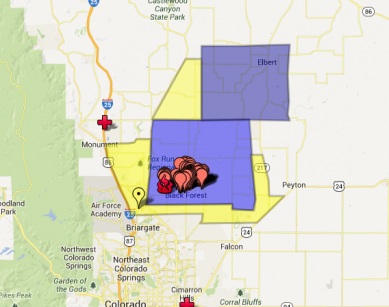
Residents in the expanded evacuation area were notified by officials overnight. The fire has burned through 15,000 acres and burned over 360 homes as of Thursday morning.
The extended evacuation zone means that over 13,000 homes have been evacuated across 94,000 acres. Around 38,000 residents have already evacuated the area, according to the Denver Post.
The expanded evacuation zone includes Highway 83 east to Eastonville Road, and Walker Road north to South County Line Road.
Residents living in some parts of Colorado Springs have also been issued a pre-evacuation notice.
The weather continues windy, which is the biggest threat to the fire. However, the weather report states that there is a ten percent chance of thunderstorms.
An evacuation center has been established at Palmer Ridge High School. An evacuation center was established at New Life Church but was closed Wednesday at 1:48 p.m. due to heavy smoke.
View Black Forest Fire Evacuation Map in a larger map